Showing posts with label san diego. Show all posts

Thursday, July 12, 2012

Camp Cooking: Pit Cooking Pork (Cochinita Pibil)

I recently went Mamping (Man camping, duh) with 2 of my good buddies up into the local mountains. It really isn't the best time of the year to go camping, the water is mostly dried up, the plants are dead and it's pretty hot, but we wanted to get out of the city. We did find a small campground out in the Cuyamaca Mountains that had plenty of shade, higher elevation (cooler temps) and within an hour drive of downtown San Diego called Cibbet's Flats. The main purpose of the trip was to have some fun, drink some beers and eat some good camp food.


Speaking of camp food, I have wanted to try pit cooking for a while now. The basic idea is you dig a hole, make a fire, wrap your meat and bury it for a while. It is the primitive way of slow cooking. So basically you can do any dish that you would normally slow cook. Think Crock-pot meals except I would advise against anything stew-like unless you have a dutch oven. To me slow cooking means pork. Pork is great because it is highly fatty, which breaks down over time into moist flavors.

After looking through a bunch of online recipes I decided on Cochinita Pibil. I'm still not quite sure if it is Mayan or Yucatecan, more than likely both.

Here are a list of the best recipes I found:
- CHOW
- Simply Recipes
- Dad Cooks Dinner

The Basics and you can scale howeer you need:

  • 3 lbs pork chopped in chunks (get the cheapest, fattiest stuff you can = more flavor)
  • Marinade - Blend until smooth(ish)
    • 1 medium onion, peeled and sliced
    • 2 bell peppers - pick your favorite colors
    • 1/2 teaspoon kosher salt
    • ~4 oz of achiote paste
    • 1 orange (sour or Seville preferred, I just used under ripe Valencia Oranges)
    • 2 cloves garlic
    • oregano -  If fresh, a small bunch, dried 1/4 tsp.
    • 2 bay leaves

Marinate for 24 hours in ziploc bags.


Wrap in Foil (Traditionally banana leaves, but these were harder to find than I thought) - don't be shy with the foil - this is the only thing preventing dirt in your food. I used the weave technique and had good success. And then I added a second layer over the whole package.

Dig a hole or use a fire pit. Then line the pit with rocks (these retain your heat).


Start a fire - A decent sized fire with some charcoal added helps. We cooked our bacon-wrapped veggie burgers over the coils for Friday night's dinner. Side note: Bacon wrapped veggie burgers are legit, you can wait till the bacon is cooked without risking the burger getting overcooked. Top with caramelized onions and Sweet Baby Ray's BBQ sauce.


Once you are done with you fire for the night. And done drinking (we got to taste a bunch of homebrews), then put the foil packs right on the coils.


Bury the "goods" with dirt to trap in all the heat.


Open the foil carefully and get ready for beautifully cooked pork.


Serve on corn or flour tortillas with eggs, potatoes and hot carrots for breakfast. And then for lunch or dinner, serve on bolillos to make great tortas.


Yum. Ideas for next pit cooking session include: Carnitas, Chile Verde, Beer BBQ Pulled Pork

Friday, February 10, 2012

Undercover San Diego: McGinty Mountain

Finally another San Diego Adventure, it has been a while since I did some exploring ( I guess I have been brewing and drinking too much beer). Luckily for me, we are having an unusaully beautiful winter in San Diego. This means it is easier to convince my favorite hiking partner to get out on the trail.

This particular hiking partner (my wife) is pretty specific in the types of hikes she likes. Here are her criteria:

  • Must be a mountain - without an elevation change you are walking, not hiking - her words
  • Must be within a close drive - over 30 min. and she gets restless
  • Must be pretty - meaning trees and flowers, nice view
  • Rather it not crowded - she doesn't like people watching her sweat.


This really narrows down our hiking choices, but it is a fun challenge for me because hiking up mountains and living on the coast doesn't work very well. I looked in my trusty Afoot and Afield: San Diego County: A Comprehensive Hiking Guide . I searched for mountain hikes that were as close to Downtown San Diego as possible. And I was pleasantly surprised to find a decent length hike (~5 mi) within a 25 minute drive - McGinty Mountain. Next, I checked one of my new favorite hiking blogs (100 peaks - unfortunately the San Diego hikes will be discontinued since the author moved.) It looked great and he has gone through a lot of effort to detail the hike. He has a great trail map and even a video of McGinty Mtn. So for my post I will just add some commentary and extra pictures of the trail. Enjoy.

The trail-head is easy to find and it has a good sized parking lot. Looking at the map at the trailhead (above) shows that there are actually several ways to hike to the summit, but I recommend staying on the main trail detailed on the sign.
The hike really has a nice mix of terrain and a good flow to the exercise. You start at a low grade, then a few switch-backs to your first peak.

Then you get to rest a bit as you walk along the ridge to the next steep grade. This grade is pretty darn steep, but there are several places to stop and enjoy the view. And during the last push to the summit, I spotted a cave that I will need to come back to when I have a headlamp. And the summit is worth it, great 360 degree views of San Diego County and into Mexico.


 I would recommend this hike to anyone looking for a nice alternative to Cowles Mountain, which is far too crowded for me.

Monday, June 13, 2011

Bike Ride: Poway (Sycamore Canyon) Native Plants

Having a office job means that it is necessary for me to get outside on my lunch breaks. I work out in Northeast San Diego County in Poway (The City in the Country). The nice part about this area is the accessibility to hiking and bike trails. From our office we can be on 3 or 4 trails within a .25 mi.

Early this Spring (end of March) we went on a ride to see the status of the native plants after we received so much rainfall this year. This actual ride was on our road bikes and is a nice 6 mile loop from the Business Park of Scripps Poway Parkway and up Sycamore Canyon Rd. It has a good hill near the turn-around area where you can continue down into Mission Trails Park.

Wild Purple Nightshade - Solanum xanti 
Great Flower and related to the tomato and eggplant. (Check here for better Nightshade pictures)


Yellow Yarrow -Eriophyllum Confertiflorum
More pictures of Yarrow


Fuchsia-Flowered Gooseberry - Ribes speciosum
Stay tuned to a future post about harvesting the berries and preparing them for a sour beer
More pictures of Fuschsia Flowered Gooseberries


Black Mustard - Brassica Nigra
This will be harvested soon and I will make my own mustard with the wild seeds


Chaparral Yucca - Our Lords Candle - Hesperoyucca whipplei
Here is a good site about how the Native Americans used Yucca


One last note a great way to identify native plants is to use the Cal Photos website. You can enter as many details as possible and then just look through pictures till you find the one you need. This site is much more helpful if you already know the basic plant family or common name.

Monday, April 25, 2011

Undercover San Diego: National Wildlife Refuge

The full name of this place was too much to put in the title, San Diego NWR (National Wildlife Refuge) -Otay-Sweetwater Unit. As most government websites, the website for this Refuge is a bit confusing and doesn't have much information. So hopefully the below description will help you get a good impression of the place.
I participated in a guided hike with "Ranger Lisa and native plant experts from RECON Environmental, Inc.". One of our good friends works for RECON and was an expert, so that made it even more enjoyable. See the map below or to find a good trailhead just map "3570 Par 4 Dr, Jamul, CA". Park at the end of the Cul-de-sac and you will see the trailhead.


View San Diego National Wildlife Refuge in a larger map

I learned a good bit from walking with these experts and it is a very fun way to take a hike. I'd say it was more like a stroll because it's just so easy to stop and ask questions. I have posted a few photos of some of the more common plants.

 Everlasting - I used a similar plant (the bi-color species) in my Native Gruit. Smells wonderful, some people think it smells like maple syrup.

 Funnel Web Spider
 Miner's Lettuce - edible, we found from testing that the bigger the leaf the less bitter.
 Native Morning Glory - these are very easy to identify due to the leaf shape (arrow-head)
 Wild Barley - look for a future post, I am looking into malting my own for beer.
 Wild Honey Suckle
 Yellow Yarrow - This was used in my Gruit


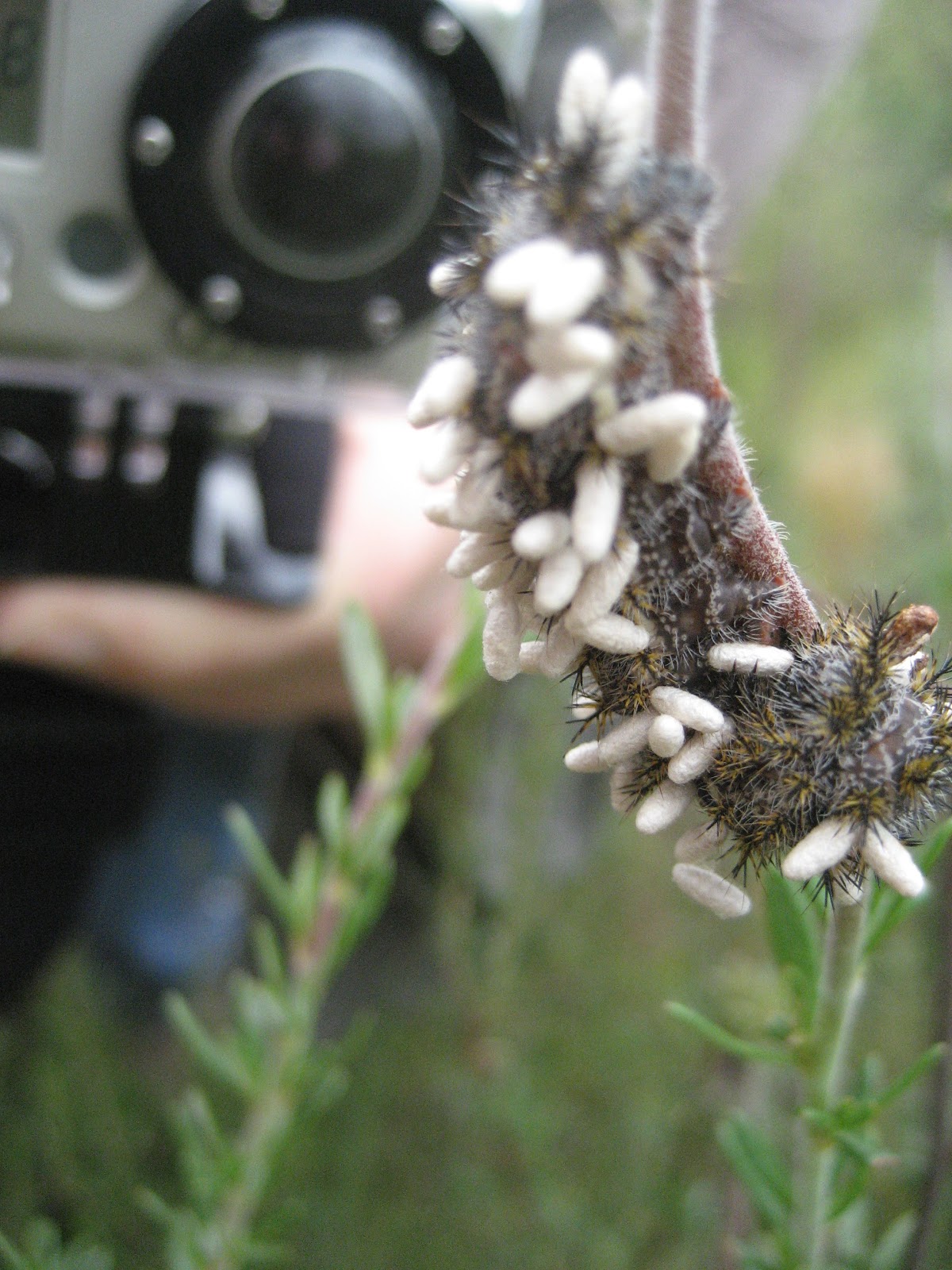
I sent this picture off to my insect expert friend, Jordan. Check the response.
"Beautiful!! That little caterpillar is infested with endoparasitic wasps. I am not sure what the parasitoid is (i.e., the animal that laid the eggs in the caterpillar), but I would guess it would be from the family Braconidae (http://bugguide.net/index.php?q=search&keys=Braconidae&search=Search). The animal inserts its eggs into the caterpillar with its long ovipositor, then after the eggs hatch and the larvae eat the animal from the inside, they make the cocoons that you see there. Then they will emerge as beautiful little adult wasps and the females will mate and then search for another caterpillar to start the whole process again. The circle of life.....isn't it beautiful!"

Wednesday, March 23, 2011

Undercover San Diego: Valley of the Moon

This is not technically a San Diego destination, but it makes a great day trip. It should take an hour to an hour and half to drive there. And the hike can take anywhere from a 4 - 8 hrs depending on how far you drive and how much exploring you want to do. It is pretty easy to get there especially if you have a good map (see below). Drive on 8 East and exit at In-Ko-Pah Park Road. Take 2 quick rights and continue south a few hundred feet on the frontage road to a dirt lot on the left. Once you enter the lot, take an immediate left onto the dirt road. Check out the Interactive map for the Valley of the Moon.


View Valley of the Moon Hike in a larger map
Now, you have a decision to make.
1) If you have a high-clearance vehicle (4WD would be helpful) you should be able to drive the 3 or 4 miles to the Valley of the Moon.
2) If you have a small passenger car or don't feel comfortable with the rough roads (which are rocky, rutted and steep for the first mile) there are a few turnouts to park on the road.

Check out the pictures below and make your decision. We parked at the first big turn-out because we were there to take a hike. (see White Explorer, click to enlarge pictures)
The hike up the hill is pretty steep, but that does mean downhill on the way home. When you make it up to the saddle you will see a spur trail marker on your left. I recommend taking this down to Smuggler's Cave and then walking through the wash to meet up with the Jeep road.


The next big fork in the road you will see a sign "154/155". To the left goes through more rocks on your way to the Valley. To the right leads you to the steep trail up to Elliot's Mine. Trust me GO RIGHT. The steep climb is worth looking through this old Quartz Mine which some maps call an amethyst mine. (click to enlarge pictures)


The mine has 2 entrances the lower goes about 100 ft and after a tight squeeze leads to the other (higher on the mountain) entrance. From here you can easily duck into the main mine. The mine has one large room to the left and then two more dead ends that are worth exploring to the right. Make sure to remember your head-lamps.

From the mine entrance take a right (East) and proceed down the trail and you will get to a great overlook of the Valley of the Moon. We then hiked down the side of the hill till we met up with the Jeep Rd again. You are now in the Valley of the Moon. So get out your lunch or climbing gear or crash pad and enjoy.

We did a bit of wondering through the canyons. The rock formations are truly amazing and are impossible not to climb around on. To get back to your car simply follow any Jeep Rd that is going west or print out the Valley of the Moon Google map.

Here is my Father-in-Law's Travel Pod Photo Album
(With way more pictures of the caves and rock formations)

Thursday, February 24, 2011

Undercover San Diego: Sheep Canyon


It's time to start planning your trips to the Anza Borrego Desert because it's getting close to wild flower season. Here is a link to a great Anza Borrego Flower Map.
The past year we did an overnight at the primitive camp in Sheep Canyon. For this trip, it is as much about the journey as it is the destination. If you have a 4 wheel drive vehicle and off-roading skills then you can drive all the way to the primitive campsite. Well, I have neither so that means that we drive as far as we feel that my 2 wheel drive SUV can go. And we stick to places that have decent traffic so if we do get stuck then the generous desert people can help us out (which happened once before).

So I created a custom Google map that has all the checkpoints for getting to Sheep Canyon.


View Road to Sheep Canyon in a larger map

One thing I learned from this trip is just how much more you can "see" by hiking rather than driving. I don't mean area, but depth. In an area like the desert that looks so scarce it is amazing what you see when you slow down your pace.

For example, in Boulder Alley where all the technical off-roading happens we got to watch (carefully) the desert blister beetle (Lytta magister) mate. Just watch, don't touch.

And my animal expert hiking partner, Jordan, also found a nice snake. It is amazing how quickly he can identify (make sure not poisonous) and grab them. The snake was much easier to catch since it was starting to cool down and that slowed the snake considerably.

The reason that most come out to Sheep Canyon is for the a bit of canyon exploration. There are a few waterfalls and pools but I've heard Cougar Canyon is much better for this. The best reason is the sunrise.

Wednesday, September 22, 2010

Undercover San Diego: Louis Stelzer County Park

This has to be one of the best maintained, and conveniently located San Diego county parks. The park is out in Lakeside or Eastern San Diego County (map). The East County can get a bit warm in the summer and early fall but that is the great part about this park, it has shade.

This park and surrounding area has lots of Elderberry tress (Mexican). I was curious to try some of the berries to see if they would work in beer. Well from the looks of the pictures I was at least a couple weeks late (but not too late for rattlesnakes). They were already dried out. So now I know for next year.
The other cool part about Louis Stelzer County Park is that there are wild grapes growing throughout the creek bed. I wanted to go sample some of these and see what they taste like. I was too early for wild grapes, they were still extremely sour (Warhead sour). With a bit more research I found out that they may take till late October or November before being ripe.

The park has several trails and all are walk-able in just a couple hours. The main trail down the canyon is great and has nice signs that educate you about different plants and their Indian uses. From here you have the choice to retrace your steps or go up the hill and loop around with a stop at a great look-out point.
This is a great park to bring your lunch for after your hike. They have plenty of picnic tables, a play set, and also a short paved trail under the oak trees. There is a cheap parking fee that I have no problem paying, knowing it goes straight to the Park System. Stay tuned for a few more parks out in forgotten Lakeside.
Related Posts Plugin for WordPress, Blogger...