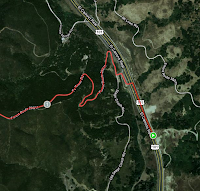
To get to Cuesta Pass, simply drive to the top of the grade just north of SLO on the 101. When you reach the top (driving north) you will notice a turn out on your left and a small turn out. Take the left and immediately right. You will then follow this rather bumpy road across the entire ridge (about 10 miles). The road is not in great condition but really any car can do the drive. Near the end of the road you do start driving on dirt so your car will be very dusty and dirty.
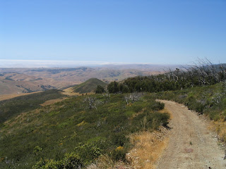
Pretty shortly you will be on top of the ridge and will see that the view is worth the bumpy ride.
From the top on a clear day you can see the dunes at Pismo and to the north you can see Morro Rock. I reason I like this adventure is because the view changes depending on the season and time of year.
 So back to the ride, around mile 3 you will see the TV towers (namesake of the road). Be careful while driving on this road because it is patrolled by the Utility and there can be some crazy drivers.
So back to the ride, around mile 3 you will see the TV towers (namesake of the road). Be careful while driving on this road because it is patrolled by the Utility and there can be some crazy drivers.
Shortly you will reach the Cuesta Ridge Botanical Area. This area is famous for the Sargent Cypress Trees. When I took the pictures in 2005 it was still recovering from a big fire.
Now keep going on this road in a couple miles it will turn to dirt. You are going to go a total of 10 miles and you will get to what looks like a dead end. And for us it has been.(more on that later). You will see a large camping area where people have had very large bonfires (illegal without a permit(free from the ranger station)).
This is where you want to park. Start walking west (the direction you have been driving) you will see a large trail through a Eucalyptus grove. As you walk through the grove you will see a steep Rock Formation to your right. You can climb/scramble up the rock and go into 2 small caves.The caves are not that impressive but make the trip a little more unique. You might as well bring a head lamp or lantern. But if you don't the caves have enough light if you let your eyes adjust.
 There are a few more trails that go off into the hills. We have hiked around there which is nice especially in spring or late winter when the hills are green and the flowers are out. The best way to get out is to go the way you came.
We have tried another way in the past, as soon as you get to the dead end there is a left hand turn down the hill. It is steep and rocky and we made it down in a 4Runner (2WD) but after a mile we were stopped by a large washout in the road. And well we tried making it back up the steep hill and failed, we had to get towed. But this could have changed and it also looks on the map that there is a road to right after the dead end....


Did you go all the way back into the cave?
ReplyDeleteI think so? Is there something I'm missing?
DeleteBelow and along Cuesta Ridge there were 40 chromite mine claims. A dozen of them were owned by S.L. Seeley, who also owned the Seeley's Auto Camp where the Del Vaglio Real Estate sign is today. Harold Lowe told me there were more mines up and around Reservoir Road. Very possible your ammo cave is an old mine. Chrome was used for tanning hides and later to make stainless steel. Pick & Shovel, Castro, El Salto, Chorro, Crown Point are some of the mines below Cuesta Ridge. ttaylor349@aol.com
Delete